Overview:
The overarching goal of the Map Room Project is to develop local spaces for grassroots map-making, where people can creatively and collaboratively explore data. Conventional digital maps can help people see rapid, large-scale social and environmental changes, even as they unfold. But often these maps are based on abstract data alone and are, therefore, disconnected from the lived experiences of their audiences. The Map Room Project aims to empower people to understand, but also challenge and even redefine the stories that maps and data tell about their lives, and about the places they live.
This project is an expansion of the St.Louis Map Room, originally created in 2017 by the Office of Creative Research in partnership with COCA. In the summer of 2018, funding from DILAC and NSF enabled us to build a new, research-oriented Map Room on the Georgia Tech campus. Our research questions include the following: what counts as civic data? what does an effective conversation around civic data look like? how can civic data become the source materials for acts of creative and collaborative expression, and to what end?
Last year, in 2019, renewed funding enabled us to create a more versatile map-making system, which we call “Map Spot.” This new, low-cost prototype enables temporary, pop-up map-making spaces virtually anywhere. We have already tested the system at high schools, museums, conferences, and design offices across the United States.
Most recently, we have begun using Map Room technology for resilience planning as part of the Smart Sea Level Sensor team, “a collaboration among Chatham Emergency Management Agency officials, City of Savannah officials, and Georgia Tech researchers who are working together to install a network of internet-enabled sea level sensors across Chatham County.”
Apparatus:
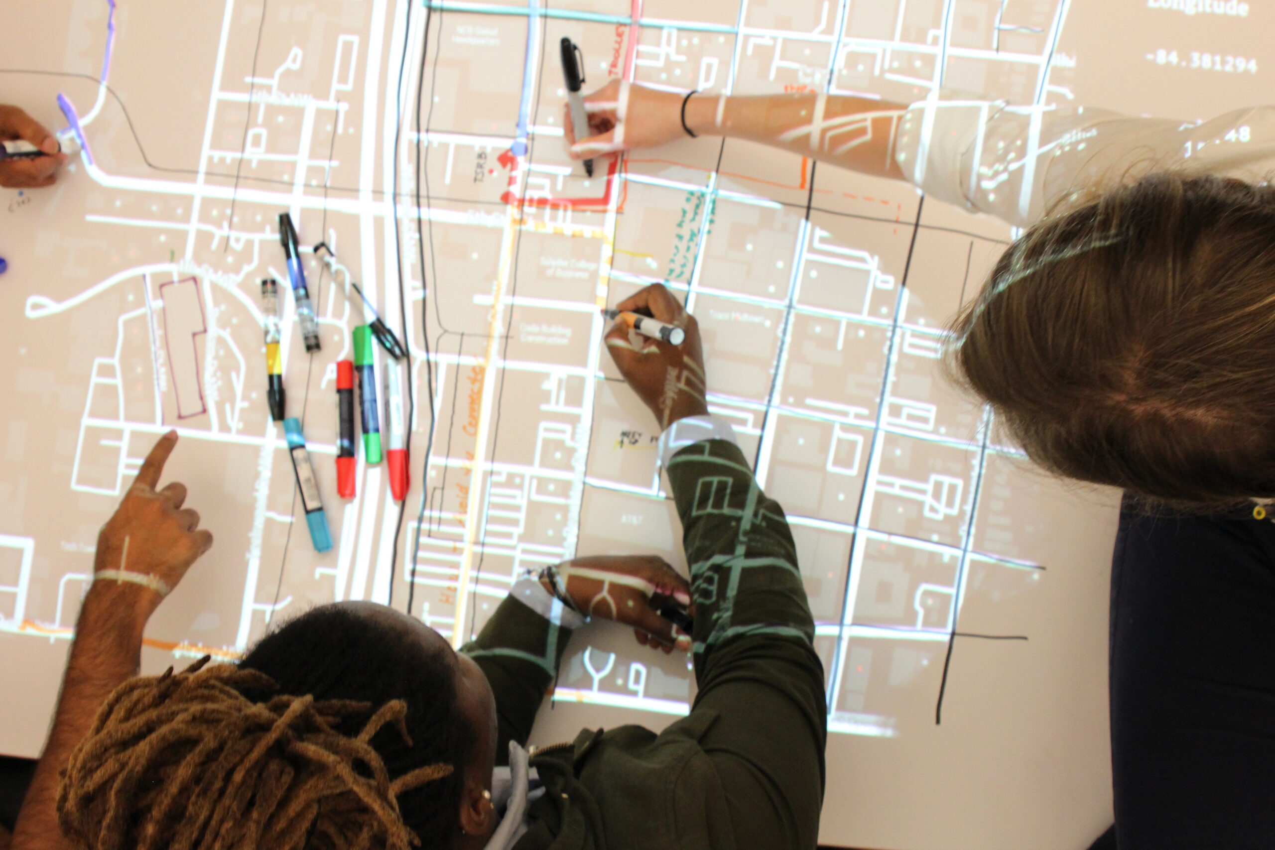
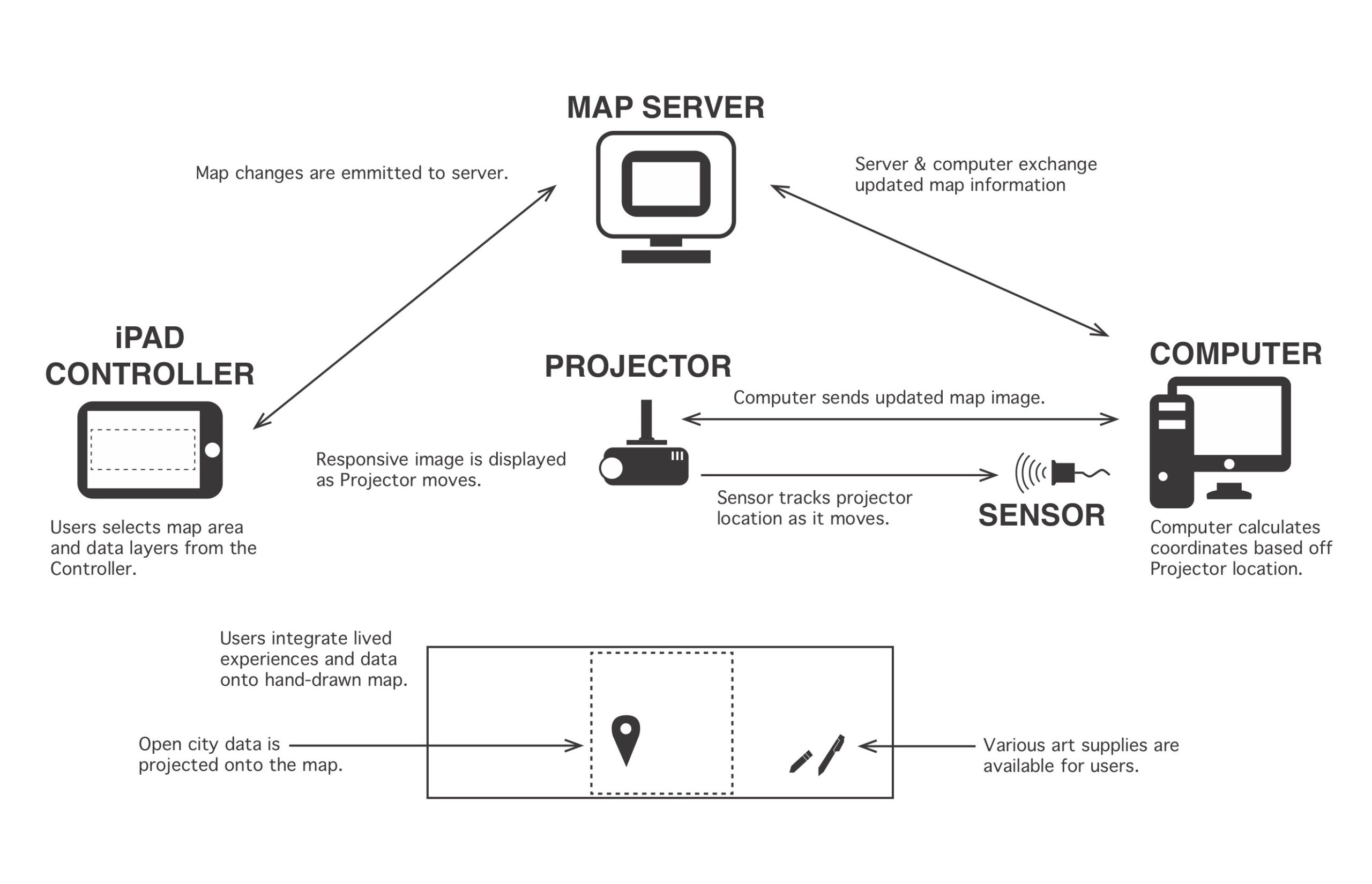
The Map Room is best understood as a hybrid map-making tool, that is both digital and hands-on. Accessibility is the priority and people, not machines, are in control. Participants use our custom-designed software, built on the infrastructure of OpenStreetMaps, to identify a geographic region they want to map. This must be an area that they already know well. They can then select from a variety of preloaded data overlays to work with, for example from government, academic, or commercial sources. The resulting image is sent to an overhead projector, which illuminates a large-format sheet of paper and guides participants as they use pens, markers, paint, collage materials—any visual media of their choice—to create physical maps that juxtapose existing data with representations of their own lived experiences.
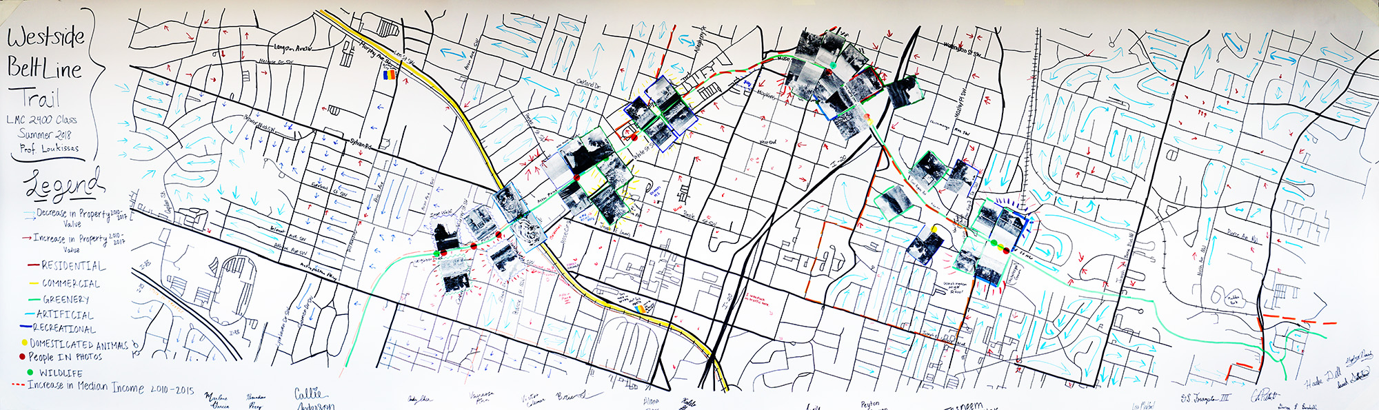
 Example Map:
Current Team:
Nicholas Boshart, Sukhmai Kapur, Yanni Loukissas, Jude Ntabathia, Jer Thorp
Past Team Members:
Muniba Khan, Lucas Phillips, Christopher Polack, Annabel Rothschild, Jihan Sherman, Raya Ward
Press:
Aviles, Mary. “Indelible Impressions: Why You Won’t Forget the Map Room Project,” Nightingale, 2020.
Recent Publications:
- Loukissas, Yanni A., “Let’s change the way Big Data present the places we live,” Big Data & Society, 2019.
- Corbett, Eric and Yanni A. Loukissas. “Engaging Gentrification as a Social Justice Issue in HCI.” ACM SIGCHI Conference Proceedings. Glasgow, UK. 2019.
- Loukissas, Yanni A., Christopher Polack, Muniba Khan, and Annabel Rothschild. “The Atlanta Map Room: Documenting the Connections and Disjunctions Between Civic Data and Lived Experiences in the City,” Atlanta Studies Blog Post, 2018.
- (Draft – Spring 2019) Loukissas, Yanni A., “Making Places For Thinking Critically About Data” in Humanities Perspectives on a Technological Work (Richard Utz ed.), Forthcoming.
2018 Video: